Case 2: The airport that looks close. How map distance misleads in the Himalaya
Planners often judge how reachable a place is by its straight-line distance to an airport. In the Sikkim valleys the road is up to six times longer, and in one case the map points to the wrong airport in the wrong country.
- Tourism access
- Spatial analysis
- Open data
- Python
- Role
- Independent analysis (Python)
- Organisation
- Self-directed research
- Period
- Oct 2026
- Location
- Sikkim, India
In short
- A quick way to judge how easy a place is to reach is to measure the straight line from it to the nearest airport.
- I tested that shortcut on six destinations in the Eastern Himalaya, using free data and Python.
- Every road was longer than the straight line, by 1.6 to 5.8 times. For one valley town, the straight line picked an airport in Bhutan that is 428 km away by road.
- The shortcut usually names the right airport, but it always makes mountain places look closer than they are.
1. The situation
How far is Gangtok from an airport? It depends on how you measure.
Sikkim has an airport. Pakyong, about 30 km south of the capital, opened in September 2018 as one of the highest airports in India. It has also gone long stretches without commercial flights. It was designed for visual flight rules, so bad weather disrupts it, and one suspension lasted about 19 months (background, resumption report). In practice, most visitors still fly into Bagdogra in West Bengal and drive the rest of the way.
People who study tourism access from a desk often use a shortcut: distance to the nearest airport, measured as a straight line on a map. It’s quick, needs no road data, and works fairly well on flat ground. I wanted to see how well it works in the mountains I grew up in.
2. The question
Does straight-line distance to an airport make a mountain destination look less isolated than it really is?
3. What I did
I wrote the analysis in Python using only free, open data, so anyone can rerun it. The code, data and charts are in the project repository.
- Listed Sikkim’s airports. I loaded the OurAirports file and filtered it to Sikkim. It lists 7 facilities, but one, Pedong Helipad, is actually in Kalimpong district in West Bengal, so I removed it. That leaves 6: Pakyong Airport and 5 helipads. None is marked as having scheduled flights in the current data.
- Picked destinations. I chose six places: Gangtok, Pelling and Lachung in Sikkim; Darjeeling and Kalimpong in the West Bengal hills; and Thimphu in Bhutan. I found each one’s coordinates with OpenStreetMap and checked every result against a box drawn around the region. That check caught an error: a plain search for “Pelling” returns a village in Tibet.
- Listed airports with real flights. I took every airport in India, Nepal, Bhutan and Bangladesh marked as having scheduled service. A local report says Taplejung in Nepal is open but has no scheduled flights, so I removed it.
- Compared straight line and road. For each destination I found the three nearest airports by straight line, then measured the driving distance to each with the OSRM routing engine on OpenStreetMap roads. Road distance divided by straight-line distance gives the circuity ratio. A ratio of 1.0 would mean a perfectly straight road.
Exhibit 1 · Straight-line vs. road distance to the three nearest scheduled airports
| Destination | Airport | Straight line | By road | Ratio |
|---|---|---|---|---|
| Gangtok | Bagdogra (India) | 77 km | 124 km | 1.6× |
| Gangtok | Paro (Bhutan) | 81 km | 358 km | 4.4× |
| Gangtok | Bhadrapur (Nepal) | 100 km | 163 km | 1.6× |
| Pelling | Bagdogra (India) | 70 km | 133 km | 1.9× |
| Pelling | Bhadrapur (Nepal) | 83 km | 172 km | 2.1× |
| Pelling | Tumling Tar (Nepal) | 103 km | 379 km | 3.7× |
| Lachung | Paro (Bhutan) | 74 km | 428 km | 5.8× |
| Lachung | Bagdogra (India) | 119 km | 195 km | 1.6× |
| Lachung | Bhadrapur (Nepal) | 141 km | 233 km | 1.7× |
| Darjeeling | Bagdogra (India) | 40 km | 71 km | 1.8× |
| Darjeeling | Bhadrapur (Nepal) | 55 km | 92 km | 1.7× |
| Darjeeling | Tumling Tar (Nepal) | 110 km | 299 km | 2.7× |
| Kalimpong | Bagdogra (India) | 46 km | 78 km | 1.7× |
| Kalimpong | Bhadrapur (Nepal) | 68 km | 116 km | 1.7× |
| Kalimpong | Paro (Bhutan) | 101 km | 311 km | 3.1× |
| Thimphu | Paro (Bhutan) | 22 km | 48 km | 2.2× |
| Thimphu | Bathpalathang (Bhutan) | 110 km | 256 km | 2.3× |
| Thimphu | Bagdogra (India) | 156 km | 305 km | 2.0× |
4. What the data shows
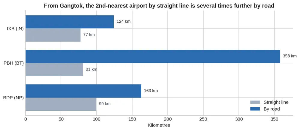
Every road is longer than the line on the map. Even to the airport each place actually uses, the road is 1.6 to 2.3 times the straight-line distance. Gangtok to Bagdogra is 77 km as the crow flies and 124 km by road.
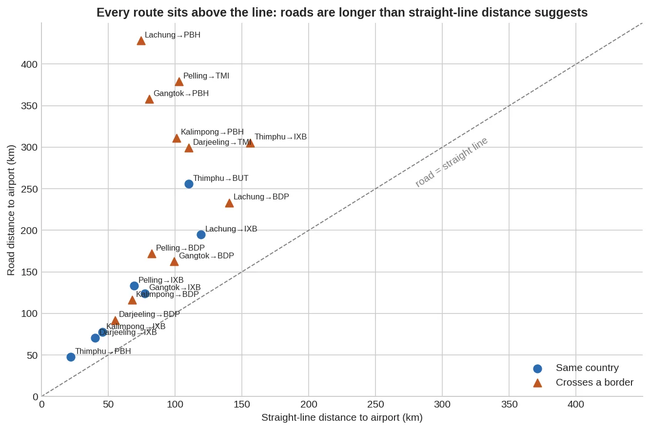
In the most enclosed valley, the straight line picks the wrong airport in the wrong country. By straight line, Lachung’s nearest airport is Paro in Bhutan, 74 km away. By road it is 428 km, nearly six times further. The airport Lachung really relies on is Bagdogra, 195 km by road.
Airports across a border look much closer than they are. Every ratio above 3 in the study is a route into Bhutan or the Nepali hills. For Gangtok, Paro ranks second by straight line and last by road.
The terrain causes most of the gap, and the border adds to it. Bhadrapur in Nepal is also across a border, but it sits on the plains, and its ratios (1.6 to 2.1) look like any domestic route. The distortion is largest where ridges and river valleys lie between a place and the airport. The border then closes off the roads that would otherwise shorten the trip.
For tourism planning, this means the shortcut is biased but still usable. For five of the six destinations, straight-line distance still names the right airport. It always understates the journey in the mountains, though, and fails outright in enclosed valleys near borders. An accessibility index built on straight lines would rank the northern Sikkim valleys as better connected than they are, and that is where it would mislead planners most.
5. Limitations
- Small sample. Six destinations and three airports each. This shows that the bias exists. It doesn’t measure how big it is in general.
- Distance, not time. OSRM’s speed estimates don’t fit Himalayan roads, so I only report distances. Real journey times, landslide closures and permit rules for different nationalities would all make the gap bigger.
- Volunteer data. Whether an airport has scheduled flights comes from OurAirports, which volunteers maintain. I made two documented corrections (Pedong and Taplejung) and couldn’t confirm Tumling Tar’s current schedule. Pakyong’s own service has been on and off since it opened.
- Old route data. I used OpenFlights only as a background check on routes, and its route file is from 2014, before Pakyong opened.
Reproduce it
Everything runs from one Jupyter notebook using public data: OurAirports, OpenFlights, OpenStreetMap via Nominatim, and OSRM. The notebook records each manual correction and its source.
Code and data: github.com/Haji12345/air-connectivity-eastern-himalaya
What you can take from this
If you want to try something similar:
- Test a common shortcut on a place you know well. Local knowledge is how you spot where the standard method breaks.
- Sanity-check every automatic lookup. A bounding-box check caught a “Pelling” in Tibet.
- Say what your sample can and can’t show. Six places can show that a bias exists. They can’t say how big it is everywhere.